

Please note that there might currently be restricted access to some unpublished items
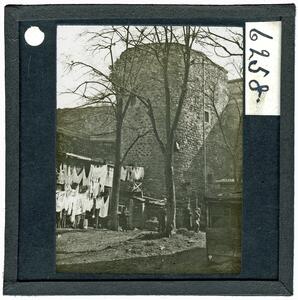
Constantinople (Galata): Tower on inner wall
[BSA SPHS/3/2347.6258], Constantinople (Galata): Tower on inner wall, Latest 1908
The original description in the SPHS register reads: "Galata: tower on inner wall
Section 13, No. 5
IV. Turkey: Constantinople Section 13, No. 5
IV. Turkey: Constantinople
IV. Turkey: Constantinople Section 13, No. 5
IV. Turkey: Constantinople
Coloured Map. War Office, January 1909.
Section 29, No. 13
Greece, Balkans, Asia Minor Section 29, No. 13
Greece, Balkans, Asia Minor
Greece, Balkans, Asia Minor Section 29, No. 13
Greece, Balkans, Asia Minor
[Greek] Coloured Map.The New Map of the Peninsula of Greece (Νεος Χαρτης της Ελληνικης Χερσονησου) showing Greece, Albania, Montenegro, Serbia, Bulgaria, Romania and the Western part of Turkey with an insert for Constantinople.
B 17.2
Constantinople B 17.2
Constantinople
Constantinople B 17.2
Constantinople
Coloured Map. Turkey. Constantinople. Geographical Section, General Staff, No. 2097. War Office, Jan. 1909.
C 6.A2
A II. Constantinopel C 6.A2
A II. Constantinopel
A II. Constantinopel C 6.A2
A II. Constantinopel
Coloured Map. Karte von Kleinasien, R. Kiepert. North Section: A.II Constantinopel